History
On 21 May 1927, Charles Lindbergh landed the wheels of his famous monoplane Spirit of Saint-Louis on the runway of the Parisian airport at Le Bourget, arriving from Long Island, near New York. After a crossing of nearly 5808 km completed in 33 hours and 30 minutes, he had just accomplished the first non-stop flight connecting America to Europe. Nearly 500 years after the first voyages of navigators to cross the vast Atlantic Ocean, France and the United States, pioneers of aviation, were now only a few hours apart.
If Lindbergh had accomplished his feat aboard a rustic single-engine piston aircraft, the development of air transport and the technical evolution of planes would lead to the normalisation of transatlantic flights, to the point of replacing ships during the second half of the 20th century. It is then that the Atlantic Ocean would become one of the most flown-over regions of the globe, with an average in 2019 of more than 1500 aircraft flying over it daily..
Due to the increase in traffic and the technical and operational specificities, the civil aviation authorities (ICAO) have been led to establish particular navigation procedures in this airspace. Indeed, the planning of such a flight differs significantly from that of a conventional instrument flight (IFR). This is what we will study in this tutorial.
In the face of the explosion of transatlantic traffic, air traffic control found itself increasingly challenged to ensure the separation of aircraft while maintaining an effective level of optimisation that did not unduly penalise the planes. The first notable step was the establishment in 1965 of a system of Tracks published daily, that is to say, optimised and mandated routes for crossing the North Atlantic. In 1977, the introduction of the MNPS (Minimum Navigation Performance Specifications) would reduce the separation distances between aircraft in exchange for higher requirements regarding navigation and communication equipments.
The most demanding airline pilots now prepare their flights using advanced planning programmes such as the essential Simbrief or the very complex PFPX. From these, flight folders are created as they exist in airlines. During a transatlantic flight, a number of elements specific to this type of operation are included and calculated in the operational flight plan (OFP). In this tutorial, we will first outline and explain the principles of transatlantic airspace, then illustrate this with concrete examples of flight preparation..
Design of the North Atlantic Airspace
NAT HLA (ex MNPS)
Before 2016, the North Atlantic airspace was known as MNPS (Minimum Navigation Performance Specification). Since then, it has been renamed NAT HLA (North Atlantic High Level Airspace), now divided into 6 controlled oceanic airspaces, still from FL285 to FL420.:
Reykavik
Gander
Shanwick
New York
Santa Maria
Bodo (newly included)

Source: NAT Doc 007 V.2022-1
As we can see on the High Altitude en-route map, there are no waypoints or published airways beyond the land overflight zones. Indeed, it is the geographical coordinates that serve as waypoints, with free routing as long as at least one waypoint is selected every 10 degrees of longitude and every 5 degrees of latitude. This part of the flight plan is referred to as a Random Route, except when the route follows the published Track system, which we will see in the next chapter..
Let's look at the example below to illustrate this:
For this flight from Frankfurt (EDDF) to Toronto (CYYZ), we have the following route where the NAT HLA section is highlighted:
OBOKA Z28 DIBIR DCT BUDIP DCT RAVLO Y70 OTBED L60 PENIL M144 BAGSO DCT REVNU DCT PIKIL DCT 5720N DCT 5830N DCT 5840N DCT 5750N DCT HOIST DCT FOXXE DCT SPOTE DCT MOFAT DCT LIDAG
 From the point PIKIL, we enter the Shanwick Oceanic airspace and then we fly over 4 waypoints corresponding to their geographical coordinates: Ex: 5720N > N57:00.0 W020:00.0
After the HOIST waypoint, we leave the Gander Oceanic FIR where we resume our navigation in the conventional airspace.
OTS (Organized Track System)
The other major specificity and reason for the existence of the NAT HLA is the famous Track system, officially named OTS (Organized Track System). For commercial reasons, the flow of transatlantic traffic tends to be in the same direction according to the time of day. Thus, the majority of East-West traffic concentrates between 11:30 and 19:00 UTC, and between 01:00 and 08:00 UTC in the West-East direction..
In order to cope with the density of aircraft flying almost all in the same direction, the question arises for Air Traffic Control (ATC) on how to manage this mass of traffic while ensuring their separation. To achieve this, a Track system has been implemented where the vertical separation distances between aircraft are reduced under certain conditions..
For your information, the majority of the world's airspace complies with RVSM (Reduced Vertical Separation Minima) rules as follows:

Source: https://www.jasma.jp/rvsm/about-rvsm/
In the NAT (North Atlantic Track), the minimum separation distances are reduced to 1000ft, thereby optimising traffic:

Source: www.sciencedirect.com
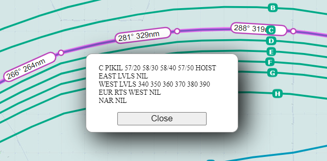
Every day, the air traffic engineers at Gander and Shanwick publish routes crossing the NAT HLA airspace optimised to make the most of the high-altitude winds. These are published in a daily document titled NAT Track Message specifying the TMI of the day (Track Message Information) as well as their applicable flight levels:
On this 19th March 2023, the TMI 078 (corresponding to the day of the year) is in effect and is presented as follows:
- The tracks A-B-C-D-E-F-G-H (in green) represent the Westbound tracks (East > West) in effect from 11:30 to 19:00 UTC for aircraft crossing 30 degrees west 1 hour before this slot.
- The S-T-U-V-W-X-Y-Z tracks (in blue) Eastbound (West > East) are in effect between 01:00 and 08:00 UTC, for aircraft crossing 30 degrees west 1 hour before this time slot.
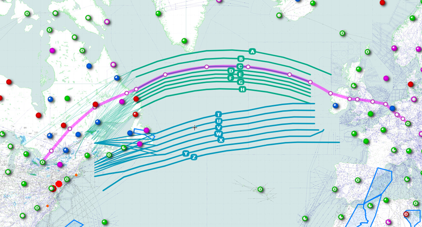
Let's return to our Frankfurt-Toronto flight. Today we are taking Track C, which has the following route:
PIKIL DCT 5720N DCT 5830N DCT 5840N DCT 5750N DCT HOIST
LThe possible flight levels are: FL340, FL350, FL360, FL370, FL380, FL390
It is worth noting that, in addition to being able to accommodate more traffic, the reduction of flight level layers allows aircraft to fly closer to their optimal altitude thanks to the closer Step Climbs, thereby saving fuel.
Note: the use of Tracks is not mandatory and it is entirely possible to plan a route outside of them. In this case, the "classic" RVSM separation rules apply..
Equipment and requirements
In return for its characteristics and rules regarding separation, the overflight of the NAT HLA airspace imposes certain requirements for navigation systems. Thus, the aircraft must meet the following criteria:
PBN: RNP4 or RNP10
Minimum 2 long-range navigation units (INS, IRS or GPS)
RVSM Approval
ATC: CPDLC (Controller Pilot Datalink Communications) mandatory from FL290 or FL410 outside areas covered by VHF
Furthermore, the carrier must be approved by the competent civil aviation authorities, and the crew must have received the appropriate training..
Blue Spruce routes
For aircraft not meeting the above criteria, crossing the North Atlantic is not excluded but comes with certain restrictions.
There is either the option to operate outside the NAT HLA airspace, that is to say below FL285 or above FL420, but this poses obvious problems of performance and optimisation.
This is why specific routes have been established, which are certainly less direct, but still allow for crossing the North Atlantic at a more optimal flight level; these are the Blue Spruce routes..

Note: in practice, these routes are mainly used by aircraft crossing the ocean exceptionally out of necessity (ferry flights, deliveries of aircraft from America to Europe and vice versa, etc…).

Examples of planning
A flight on the Tracks
On this flight from Paris Charles de Gaulle (LFPG) to Chicago O’Hare (KORD), the operational flight plan (OFP) prepared by dispatch provides us with the following route:

The STD of 1100 UTC involves a crossing of the NAT HLA during the implementation of the Westbound Tracks of the day (from 11:30 to 19:00 UTC).
In our case, we have planned Track F as follows:
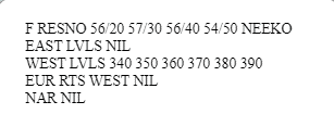

Before crossing RESNO waypoint, which signifies entry into the NAT HLA airspace, air traffic control will assign us an oceanic clearance confirming our route. It is possible that this may differ from the planned route in the flight plan, mainly for traffic regulation reasons.
Note: This is also the time when the crew checks the status of the systems (as mentioned above) required to enter the NAT HLA. If not, either the ATC will impose a rerouting, or we will be required to turn back if the necessary fuel is too significant.
Random route
During this crossing from Halifax (CYHZ) to London Heathrow (EGLL), the most efficient route is outside the published Tracks. We will therefore plan a Random Routing in the NAT HLA, between the waypoints ALLRY and MALOT:

As in the first case, an oceanic clearance is necessary and we are subject to potential rerouting.
Note: Care must be taken during planning to remain at least 10 degrees south of Track F in order to avoid conflict with the converging traffic of the Westbound Tracks if they are active.
Partially on Tracks
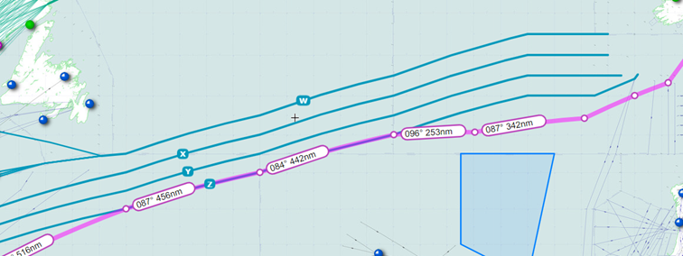
To illustrate this scenario, we have a flight plan from Curacao (TNCC) to Amsterdam Schipol (EHAM), with a STD of 01:00 UTC, which will take us across the NAT HLA during the implementation of the Eastbound Tracks..
The optimal route is a Random Route but joining the end of Track Z from waypoint 48N015W:


IIt is possible to plan a route partially on a Track provided that you join and/or leave it if it is an external Track. It is prohibited to cross an active Track or to join one from the inside.
Examples:
ALLOWED
NOT ALLOWED

Note: Outside of the Tracks' activity hours, they may be ignored even though they appear on the map, and any route then becomes a Random Route, even if published waypoints are used.
References
Here are the main official sources for further exploring transatlantic flights:
-Le NAT Doc 007, NORTH ATLANTIC OPERATIONS AND AIRSPACE MANUAL published by ICAO, the official text defining the NAT HLA
-The NAT messages published by the US FAA
-SkyVector, online map displaying in particular the current Tracks