Definitions
The anticipation of weather conditions is inherently a fundamental prerequisite for flight safety. Hazardous phenomena (storms, wind, fog, etc.) are potentially numerous, and any flight preparation must involve a thorough study of the weather along the route, regardless of the type of operation.
The early days of aviation were marked by numerous accidents as the available weather information remained very limited, and pilots often faced unexpected adverse conditions, sometimes extreme. The development of technical means has significantly improved not only the quality of observations but especially that of forecasts.
The measures put in place have made information accessible to pilots and flight dispatchers through various means (charts messages, etc.) that we will examine in this article. Beyond technical and human limits, the authorities use them to establish regulatory minima.
METAR (Meteorological Aerodrome Report)
This is an observation message. If different formats existed previously, the format was standardised in 1968 by ICAO and still holds global authority..
It reports the observed conditions at an airfield and is updated every hour, except in the case of a SPECI which can be issued at any time in the event of significant changes.
Decoding
The METAR follows a precise format and is structured as follows :
TYPE AIRPORT DAYTIME AUTO WIND VIS RVR WX CLOUDS TEMP QNH EXTRA
TYPE > METAR or SPECI
AIRPORT > Aerodrome code ICAO > XXXX
DAYTIME > Day and hours(UTC) > DDHHHH
AUTO > AUTO / COR / NIL
- AUTO > Message issued by an automatic station
- COR > Correction replacing the previous message
- NIL > No messages issued
WIND > Direction or speed in knots > XXX/YYKT
VIS > Horizontal visibility in metres > XXXX (or 9999 if greater than 10 km)
RVR (If LVP active) > Runway Visual Range in metres on a specific runway > RWXX/YYYY
- PYYYY > greater
- MYYYY > lower
- YYYYVYYYY > comprise between
- YYYYU > increase
- YYYYD > decrease
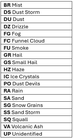
WX > Significant weather > +-XX
- Description
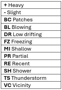
2. Phenomena
CLOUDS >
-Cloud coverage in octas and height (AGL) of the cloud base in hundreds of feet > XXXYYY
- FEW > 1 à 2/8
- SCT > 3 à 4/8
- BKN > 5 à 7/8
- OVC > 8/8
-Presence of convective clouds
- CB > Cumulonimbus
- TCU > Towering Cumulonimbus
-Vertical visibility (VV) > Vertical visibility in hundreds of feet(ft) > VVXXX
-No cloud
- NSC > No clouds reported below 5000 ft (excluding CB and TCU)
- SKC > No reported clouds
- NCD > No clouds reported (automatic station)
- CLR > No clouds reported below 12,000 ft
- /// > Unspecified cloud type
-CAVOK
- Visibility greater than 10 km
- No clouds below 5000 ft
- No convective clouds
- No significant weather
TEMP > Temperature and dew point in degrees Celsius > XX/YY (M in front of the temperature if negative > MXX/MYY)
QNH > Atmospheric pressure at sea level in hectopascals (hPa) > QXXXX
EXTRA >
- Possible additional information
- Recent weather > REXX
- Wind shear> WSRXX / WS ALL RWY
- Tendency > On the same model as the TAF or NOSIG if no changes are expected
- Runway Condition > SNOWTAM format
Examples
METAR LFQQ 020700Z COR 240/22G37KT 200V290 3000 +SHRA TS BKN012CB OVC025 08/07 Q1000 WS RW26
-METAR Lille Lesquin
-Published on the 2nd at 07:00 UTC
-Correction
-Wind from 240° for 22 knots with gusts up to 27 knots, variable between 200 and 290 degrees
-Visibility 3000 metres
-Heavy rain showers
-Storms
-Clouds scattered at 1200 ft AGL, overcast at 2500 ft AGL
-Temperature 8°C / dew point, 7°C
-QNH 1000 Hpa
-Wind shear reported runway 26
METAR EDDM 251100Z 210/02KT 0600 R26L/1200D R26R/1100U FZFG VV002/// M03/M03 Q1028 TEMPO 0900
-METAR Munich F.J Strauss
-Published on the 25th at 11:00 UTC
-Wind from 210° for 2 knots
-Visibility 600 metres
-Runway Visual Range 26L 1200 metres (decreasing) / runway 26R 1100 metres (increasing)
-Freezing fog
-Vertical visibility 200ft AGL, clouds unspecifieds
-Temperature -3°C / dew point -3°C
-QNH 1028 hPa
-Temporary visibility of 900 metres
METAR LFHP 221700Z AUTO 140/08KT 9999 NCD 25/16 Q1011 BCMG 180/15KT 8000 DZ BKN010
-METAR Le Puy Loudes
-Published on the 22nd at 17:00 UTC
-Automatic message
-Wind from 140° for 8 knots
-Visibility greater than 10 km
-No cloud reported
-Temperature 25°C / Dew point 16°C
-QNH 1011 hPa
-Becoming: wind 180°/15KT, visibility 8000 metres, drizzle, scattered clouds at 1000ft AGL
Regional characteristics
- In the United States and Canada :
- The visibility is published in status miles (SM) > XXSM
- The QNH is called Altimeter and published in inches of mercury (Hg) > AXXXX
Notes: These two countries use certain specific abbreviations in the METAR that we will not address within the framework of EASA.
Example: METAR 040652Z 24004KT 8SM FEW250 03/02 A3030 RMK AO2 SLP262 T00280022 ?=
- In Russia (as well as in several CIS countries) and in China, wind speed is given in metres per second > XXX/YYMPS
Example : METAR ZUCK 040700Z 22002MPS 150V310 9999 SCT033 22/11 Q1018 NOSIG=
TAF (Terminal Aerodrome Forecast)
Introduced at the same time as the METAR, the TAF published in addition to the METAR is an aerodrome forecast message. There are two types of TAF :
- The short TAF: issued every 3 hours and valid for 9 hours
- The long TAF: issued every 6 hours and valid for 24 or 30 hours
Decoding
If the reading is identical to that of the METAR, the TAF is therefore arranged to show a weather forecast and is divided into two sections :
- The general forecast for the entire validity period :
TAF AMD DAYTIME VALIDITY WIND VIS WX CLOUDS
2. The evolution within the period if applicable :
- FM > From
- BECMG > Bcoming
- TEMPO > Temporary
- PROB30 > Low probability
- PROB40 > Average probability
- PROB30 TEMPO > Temporary low probability
- PROB40 TEMPO > Temporary average probability
Remarks: ! The TAF does not contain forecasts for QNH and RVR !
Certain countries publish a forecast of maximum temperature (TX) and minimum temperature (TN) at the end of the forecast > TXYY/HHHHz TNYY/HHHHz
Example
TAF EHAM 040452Z 0406/0512 19013KT 9999 BKN045
PROB30 TEMPO 0406/0411 FEW008 BKN012
BECMG 0413/0416 16013KT=
-TAF Amsterdam Schipol
-Published on the 4th at 04:45 UTC
-Validity from the 4th at 06:00 UTC to the 5th at 12:00 UTC
-Wind from 190° for 13 knots
-Visibility greater than 10 km
-Fragmented clouds at 4500 ft AGLL
-Temporary low probability, on the 4th between 06:00 UTC and 11:00 UTC, few clouds at 800 ft AGL, fragmented at 1200 ft AGL
-Becoming on the 4th between 13:00 UTC and 16:00 UTC, wind 160° for 13 kt
SIGMET
The SIGMET is a warning message issued in the event of observations or forecasts of significant meteorological phenomena. Unlike METAR and TAF, which pertain to aerodromes, the SIGMET covers a flight information region (FIR or UIR).
There are 3 types depending on the threat :
- SIGMET for en-route weather
- SIGMET for tropical cyclones
- SIGMET for volcanic ash
Decoding
The SIGMET consists of 3 lines. The structure of the message is fixed, but the description of the weather conditions is in plain language while using a number of abbreviations :
1.TYPE COUNTRY NR STATION TIME
TYPE > Type of SIGMET
- WS > En-route
- VA or WV > Volcanic Ash
- TC or VC > Tropical cyclones
COUNTRY > Country of origin of the message
NR > message number
STATION > Station broadcasting
TIME > Broadcast time
2. IR SIGMET NR VALIDITY STATION
FIR > FIR affected by meteorological phenomena
SIGMET NR > SIGMET Number
STATION > Station observing
3. AREA WX FORECAST/OBS LOCATION FL MOVING TREND
AREA > Area of occurence
WX > Nature of phenomena
FORECAST/OBS > Forecast or information
LOCATION > Position of phenomena
FL > Flight level or altitude of phenomena
MOVING > Displacement of phenomena
TREND > Expected evolution
Exemples
WSGR31 LGAT 080725
LGGG SIGMET T04 VALID 080725/080925 LGAT-
LGGG ATHINAI FIR/UIR EMBD TS OBS W OF LINE N3931 E02208 - N3807 E02224 - N3711 E02239 - N3630 E02220 - N3528 E02111 MOV E NC=
-SIGMET weather en-route, Greece, bulletin no. 31, issued by the Athens station on the 8th at 07:25 UTC.
-Observed in the Athens FIR, SIGMET No. 4, valid on the 08th from 07:25 to 09:25 UTC, observed from the Athens station.
-Athens FIR, submerged thunderstorms observed to the west of the positions N3931 E02208 - N3807 E02224 - N3711 E02239 - N3630 E02220 - N3528 E0211, moving east, no change expected.
WCAU01 YMMC 191304
YBBB SIGMET O04 VALID 191325/191925 YMMC-
YBBB BRISBANE FIR TC FINA PSN S0936 E13242 CB OBS AT 1200Z WI 060NM OF TC CENTRE TOP FL600 STNR NC
-SIGMET tropical cyclone, bulletin no. 1, issued by the Melbourne station on the 19th at 13:04 UTC.
-Observed in the Brisbane FIR, SIGMET No. 04, valid on the 19th from 13:25 to 19:25 UTC, observed from the Melbourne station.
-Brisbane FIR, tropical cyclone Fina, position S0936 E13242, Cumulonimbus, observed at 12:00 UTC, within a radius of 60nm from the centre of the cyclone, ceiling FL600, intensifying, stationary.
WVID21 MMMX 14111800
SIGMET VA VALID 141800/142400 MMMX –
FROM 1900N09800W TO 1900N09500W TO 1700N09500W TO 1700N09800W FL200 TO FL400 VA CLD OBS AT 141755 POPOCATEPETL MOV NW 25KT FCST MOV NW 25KT
RMK : VA CLD OBS POPOCATEPETL 141755 ERUPTION ONGOING.
-SIGMET volcanic ash, bulletin no. 21, issued by the Mexico station on 14 November at 18:00 UTC.
-Valide le 14 de 18:00 UTC à 24:00 UTC, observé par a station de Mexico.
-from 1900N09800W to 1900N09500W to 1700N09500W to 1700N09800W from FL200 to FL400, volcanic ash cloud observed on the 14th at 17:55 UTC originating from the Popocatepetl volcano, moving northwest at 25 kt expected to continue moving northwest at 25 kt.
-Note: Volcanic ash cloud observed from Popocatepetl on the 14th at 17:55 UTC. Ongoing eruption.
References
-ICAO Doc 8896 - Manual of Aeronautical Meteorological Practice