Definitions
In aviation, particularly for instrument flight (IFR), the different phases of flight are subject to minimum safety altitudes that ensure a minimum height of clearance over obstacles, whether they are physical (ground, terrain, structures) or not (airways, procedure).
The purpose of this article is to list the different types and define them according to the regulations.
Before going any further, here is a reminder of the different concepts of altitude used :
- Altitude (AMSL) – Altitude Above Mean Sea Level : Height above mean sea level
- Height (AGL) – Altitude Above Ground Level : Height relative to the groundl
- Flight level (FL) – Flight Level : Altitude relative to the reference of 1013.25 hPa
Types of minimum altitudes
MSA (Minimum Safe Altitude)
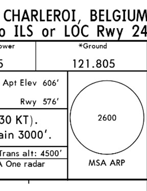
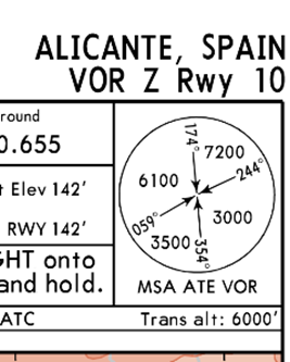
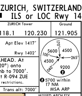
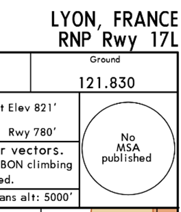
It is the most well-known safety altitude as it appears on all instrument approach charts and serves as a safeguard for pilots during take-off and landing phases, particularly in low visibility conditions.
The MSA ensures a minimum height of 1000 ft AGL above the highest obstacle (2000 ft in mountainous environments) within a radius of 25 km around a reference point.
It is indicated by a circle in the top corner of the approach chart, but may vary depending on the case :
- Unique MSA (with the airport as a reference here)
- MSA variables by area (with the VOR "ATE" as a reference here)
- MSA subject to additional restrictions (here, in the area of 9200 ft AGL, it changes to 5700 ft AGL within a radius of 17 km)
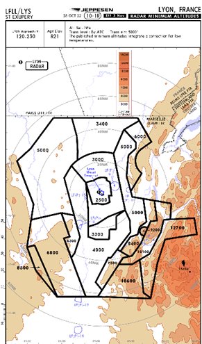
- Less frequently, no MSA published. One must then refer to the Radar Minimum Altitudes chart. The latter also allows the pilot to verify the safety altitude during radar vectoring provided by the ATC.
- For departure procedures, Jeppesen now integrates the MSA directly on the chart, represented by the red circle :

MORA (Minimum Off Route Altitude)
In the same spirit as the MSA, the MORA serves as a reference for the cruise phase.
Jeppesen has defined 2 types and is authoritative in the regulations :
Route MORA :
It ensures a vertical separation of 1000 ft from obstacles up to an altitude of 5000 ft AMSL (2000 ft above 5000 ft AMSL) over a distance of 10 nm on either side of the centreline of the ATS route.
Grid MORA :
On Jeppesen en-route charts, it indicates the MORA in each delineated area for every 1° of latitude and longitude. It uses the same crossing margins as the MORA Route.
MOCA (Minimum Obstruction Clearance Altitude)
On an ATS route, the MOCA indicates the minimum AMSL altitude required to ensure obstacle clearance and is the result of the sum of :
The maximum altitude of obstacles or terrain (the highest of the two)
+
1000 ft for an altitude up to 6000 ft
+
2000 ft for altitudes exceeding 6000 ft rounded up to the nearest hundred feet
It is established in a corridor starting from a VOR 5 nm on either side of it and diverging by 4° from the axis up to a distance of 20 to 70 nm, then becoming parallel again up to a distance of 140 nm, before finally diverging again by 4° and reaching a maximum width of 40 nm at a distance of 280 nm from the VOR. It remains constant beyond this distance.
The MOCA cannot be less than 2000 ft.
MEA (Minimum En-route Altitude)
This is the lowest altitude (or Flight Level) applicable on an ATS route or a portion of it. It takes into account both the clearance of obstacles, the structure of the airspace, and the proper reception of communication and radionavigation means.
The MEA covers a lateral space on each side of the road :
- 10 nm for segments up to a distance of 100 nm (5 nm in the TMA)
- 10% of the segment length up to 60 nm
MAA (Maximum Authorized Altitude)
Altitude (or flight level) the highest authorised on an ATS route or a portion of it where a MEA is published.
Reading on the IFR charts
On Jeppesen charts, each of these altitudes appears in a distinct format :
Example for 9000 ft :

Example on a High IFR chart:
On the ATS route T721 to ZUE, the MEA is 7000 ft, the MOCA is at 4500 ft and the MAA is FL235.
The sector's Grid MORA is established at 11,200 ft.

Example of dividing the area into sectors of Grid MORA :

References
EASA Air Operations - Part AMC1.1 CAT.OP.MPA.145(a) - Establishment of minimum flight altitudes